The map of southern Lebanon is being redrawn by text messages and social media posts. For weeks, the Israeli military has been issuing sweeping evacuation orders that have turned once-vibrant agricultural hubs and historic villages into hollowed-out shells. This isn't just about a few border towns anymore. The scale of the displacement has reached a tipping point where the social and economic fabric of the region is literally tearing apart.
If you're looking at the headlines, you'll see numbers. Hundreds of thousands displaced. Dozens of villages warned. But the reality on the ground is much more visceral. People are leaving behind unharvested olive groves and businesses they spent decades building, often with only a few minutes' notice. These aren't just tactical shifts. They're the creation of a massive "no-go" zone that stretches far deeper into Lebanese territory than most analysts predicted a month ago.
The Geography of Disappearance
The latest orders from the IDF (Israel Defense Forces) have pushed the evacuation zone well beyond the immediate border. We're seeing instructions for residents to move north of the Awali River. That's a huge distance. It places people far beyond the Litani River, which was historically the benchmark for "southern" operations.
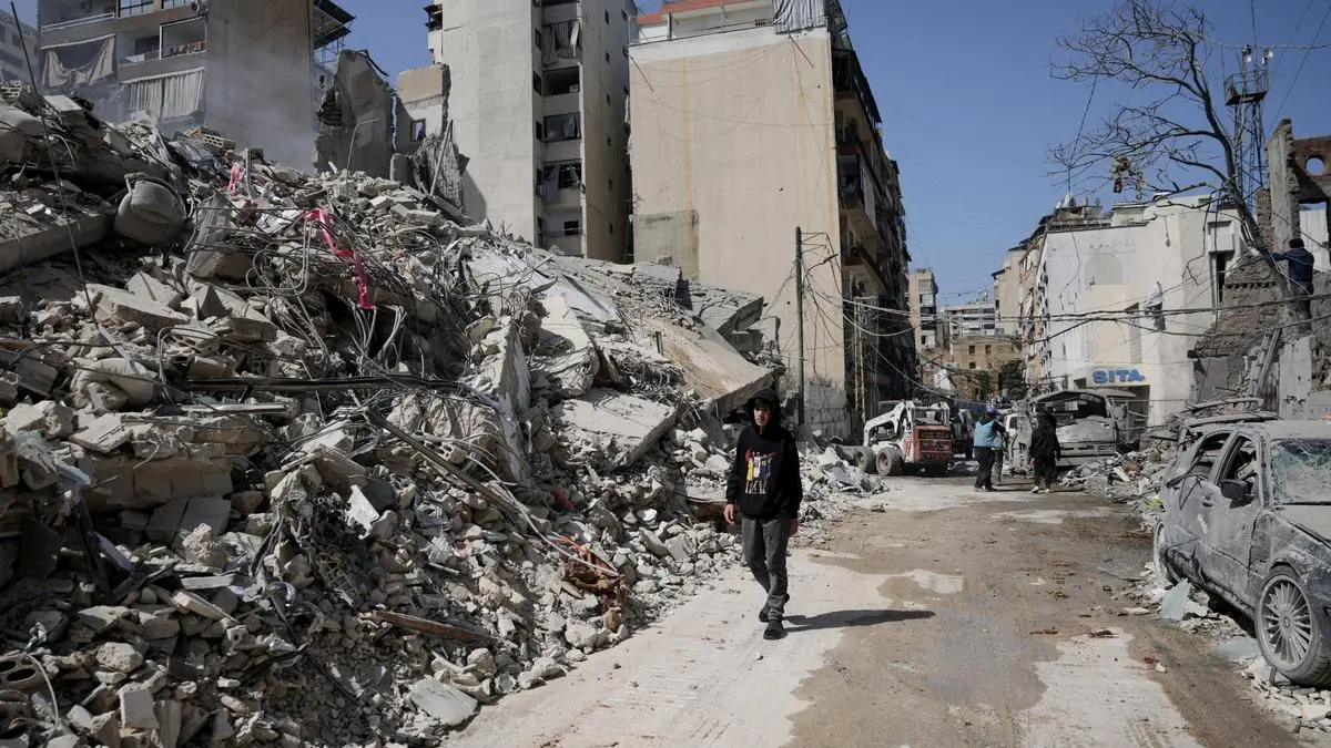
When an entire district gets told to leave, it doesn't happen in an orderly fashion. Roads clog. Fuel runs dry. People end up sleeping in cars or cramped schools in Beirut and Sidon. The towns left behind—places like Bint Jbeil, Khiam, and even larger hubs closer to the coast—are now ghost towns.
There's a specific kind of silence in these places. No shops are open. No kids are playing in the streets. The only movement comes from emergency crews or the occasional resident who risked their life to go back and grab a passport or a winter coat. Most won't go back for a long time. The infrastructure in these areas is taking a beating, and without people there to maintain things, the decay sets in fast.
Why the Buffer Zone Logic is Crumbling
The stated goal of these evacuations is to clear the area of Hezbollah infrastructure. Israel argues that by moving civilians out, they can target launch sites and tunnels without massive collateral damage. That makes sense on paper. In practice, it's a catastrophe for the Lebanese state.
Lebanon was already broke. The economy was a mess before the first drone ever crossed the border. Now, the most productive tobacco and olive-growing regions are abandoned. Farmers are watching their livelihoods rot because they can't get to their fields. This isn't just a temporary housing problem. It’s a total wipeout of the local economy.
Many observers, including human rights groups like Amnesty International and Human Rights Watch, have raised alarms about whether these orders constitute forced displacement. While a military can tell civilians to move for their safety, they also have to ensure those civilians have a safe place to go and access to food and water. Right now, that’s not happening. The Lebanese government is effectively paralyzed. It can't provide for the million-plus people who have been uprooted.
The Litani vs The Awali
There's a big difference between the Litani River and the Awali River. Most international resolutions, like UN Resolution 1701, focus on the Litani. By pushing the evacuation line to the Awali, the Israeli military is effectively claiming a much larger theater of operations.
- Litani River: Roughly 18 miles from the border.
- Awali River: Much further north, near Sidon.
This expansion tells us that this isn't a "limited" incursion. It's a broad reshaping of the southern landscape. For the people living in between those two rivers, the uncertainty is a nightmare. They don't know if their homes will be there when the dust settles, or if the "ghost town" status will become permanent.
The Human Cost Nobody Measures
We talk about buildings and borders, but we don't talk enough about the psychological toll. Imagine getting a phone call or seeing a tweet that says your entire neighborhood has two hours to vanish. You have to choose what stays and what goes. You grab the kids, the dog, and maybe some cash.
I've talked to people who have been displaced three times in three weeks. They move to a "safe" village, then that village gets an evacuation order. They move again. It's an exhausting, soul-crushing cycle. The sense of security is gone. Even if a ceasefire were signed tomorrow, the trust is broken.
The humanitarian agencies are overwhelmed. Groups like the Lebanese Red Cross and UNIFIL are trying to maintain some presence, but their movements are restricted. When the IDF issues an evacuation order, it often applies to everyone—including those trying to provide aid. This creates "black holes" where we don't really know what's happening to the civilians who were too old, too sick, or too stubborn to leave.
What Happens When the Smoke Clears
There’s a very real fear that these ghost towns won't be repopulated anytime soon. In past conflicts, people rushed back the moment the bombs stopped. This time feels different. The level of destruction in the border villages is extreme. We’re seeing entire blocks leveled to ensure no one can use the cellars or tunnels.
If the homes aren't there, the people won't come back. If the people don't come back, the "buffer zone" becomes a permanent reality, regardless of what the official maps say. This would fundamentally change Lebanon's demography and its politics for a generation.
The international community keeps calling for a return to Resolution 1701, but that seems like a fantasy right now. You can't just flip a switch and move hundreds of thousands of people back into a ruin. The Lebanese army isn't equipped to take over these areas, and Hezbollah isn't going to simply vanish because of a text message.
How to Track the Situation and Stay Safe
If you have family in the region or you're trying to follow the movement of the front lines, stop relying on general news aggregators. They're too slow.
- Follow Official Channels Directly: Monitor the IDF's Arabic-language spokespersons on X (Twitter) and Telegram. They post the maps first.
- Check Local NGO Updates: Groups like "Lebanese Red Cross" or "L’Orient Today" provide more granular detail on which roads are actually passable.
- Verify the Map: Don't trust a screenshot. Check the specific coordinates or village names against a live map like Google Maps or OpenStreetMap to see exactly where the "red zone" ends.
The situation is moving fast. These ghost towns are a warning of what happens when modern warfare meets a densely populated, fragile state. Don't wait for the mainstream media to catch up to the reality of the displacement. The maps are changing every day. Stay informed by checking the direct sources and preparing for the reality that "temporary" evacuations often last much longer than promised.
Contact local relief organizations if you want to support those currently sleeping in parks and schools. They need blankets, medicine, and clean water immediately. The crisis isn't coming—it's already here.