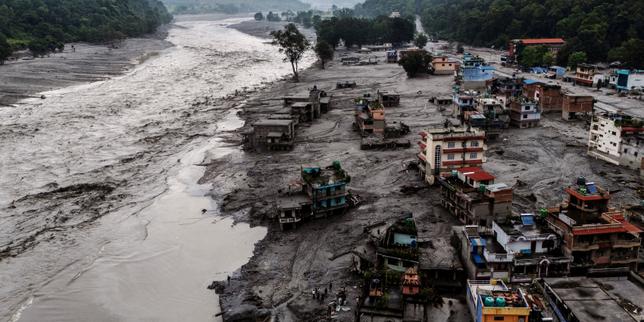
When a mountain glacier collapses onto steep Himalayan rock, it doesn't just make noise. It shakes the earth like an earthquake and sends a wall of mud, ice, and boulders racing down the valley.
That is what slammed into Nepal's Trishuli valley on August 26, 2026. Triggered by a rock-ice avalanche around the Langtang Lirung massif, the surge registered with energy equivalent to a magnitude 5.2 earthquake and tore along roughly 100 kilometers of river channel across Rasuwa, Nuwakot, Dhading, and neighboring districts. In places, the river jumped by roughly nine meters in just 30 minutes, wiping out bridges, customs infrastructure, homes, and livelihoods along a vital corridor linking Nepal and Tibet.
Nearly three months later, as winter snows creep closer to the high ridges, the emergency helicopters have mostly gone quiet. What's left is the hardest part of any mountain disaster. Returning to life in the Trishuli valley isn't simply about pouring new asphalt or putting up roofs—it's about fixing broken trade networks, living with unstable slopes, and keeping families and small businesses afloat when international attention moves on.
What Actually Happened When the Mountain Gave Way
People often call these events a "mountain tsunami," and honestly, the phrase captures the shock of seeing a river surge dozens of feet above normal with almost no warning. Geologically, though, it behaves more like a fast-moving, hyper-concentrated debris avalanche than an ocean wave.
According to assessments from the U.S. Geological Survey and researchers tracking the event, a large mass of glacier ice and rock broke loose on steep terrain above the Lhende Khola–Bhote Koshi–Trishuli drainage. Sliding and grinding friction melted ice rapidly. As the flow tore downhill, it scooped up sediment, boulders, and timber, turning into a dense, grinding slurry.
Why Early Warnings Failed in Narrow Gorges
In theory, river gauge stations and hydro-meteorological networks give downstream towns precious minutes to move to higher ground. In practice, high-velocity debris flows don't play fair.
Reporting from researchers and agencies monitoring the flood notes that the surge moved at blistering speed through tight gorges and overwhelmed upper monitoring stations before alerts could reliably reach communities further down the line. At Galchhi, roughly 88 kilometers downstream, the river's rapid jump left very little margin for error.
Even after the main wave passed, temporary barrier lakes formed behind landslide and flood debris. Those unstable dams create secondary threats—a small breach can suddenly swell water levels again and force rescue teams to halt operations mid-search.
The Human and Economic Toll
Numbers can feel cold when you're talking about mountain towns, yet the scale of loss explains why recovery is dragging:
- Lives lost and missing: Official and international tallies report well over 1,400 deaths and several thousand people still missing across Nepal, with tens of thousands displaced or living in temporary shelters.
- Swept-away infrastructure: Bridges, roads, border facilities around Rasuwagadhi, health posts, schools, water systems, and thousands of homes were damaged or destroyed.
- Massive rebuild price tag: Rapid damage assessments put total recovery and reconstruction needs in the hundreds of billions of Nepalese rupees—far exceeding initial emergency pledges.
Why Rebuilding the Trishuli Valley Demands More Than Concrete
Here is a mistake outsiders make again and again after major disasters: treating reconstruction like a checklist of physical structures. Count the destroyed bridges. Price out the damaged classrooms. Draft a tender.
That matters, of course. Without passable roads and intact bridges, food, medical supplies, and construction materials can't reach settlements like Syapru Besi, Timure, Devighat, or Trishuli Bazaar.
Still, if you stop at physical engineering, you miss what keeps a valley alive day to day.
The "Missing Middle" Between Aid and Mega-Projects
Think about what happens to a local shopkeeper, guesthouse owner, or small trader in a place like Trishuli Bazaar or Betrawati. Emergency relief might drop off tarps, food packs, or clean water for a few weeks. Years later, big infrastructure loans might fund major highway or hydropower repairs.
Sitting right in the middle is the small business. Its inventory is gone. Its customer base is scattered or broke. Suppliers want payment, bank loans don't magically vanish, and the shop owner has to figure out how to earn a living again.
A bridge isn't just steel and concrete—it's the link between a farmer's harvest, a shop's stock, and a family's weekly income.
If small enterprises can't restart, towns stay hollow even after roads reopen. Risk-sharing tools—like temporary loan restructuring, credit guarantees, and practical micro-insurance—are just as critical to recovery as heavy excavators.
Hidden Dangers Most Coverage Overlooks
A common misconception is that once floodwaters recede, the danger is over. In steep Himalayan valleys, the aftermath brings its own hazards.
Thick layers of gray, sediment-heavy mud and debris can remain deep and unstable for months, making searches and ground stabilization treacherous. As winter approaches, freezing temperatures and snowpack add another layer of difficulty in high-altitude zones while nutrition and health risks rise in crowded temporary shelters.
There's also a quieter psychological and social strain. Relief workers and local officials are often dealing with personal grief and lost homes of their own at the exact same moment they're expected to coordinate response and recovery. Expecting superhuman efficiency without supporting local responders is a recipe for burnout.
What Recovery Looks Like on the Ground
Recovery in a steep mountain corridor rarely looks neat or linear. It happens in patches—one cleared stretch of track at a time, one temporary crossing rigged over a roaring channel, one family trying to piece together normal routines.
You see the contrast starkly between official timelines and family realities. While formal emergency rescue phases wrap up, relatives of the missing often keep pushing for answers through whatever local networks, drones, or mapping help they can organize before winter shuts down the passes. Both urges come from the same place: nobody wants loved ones or livelihoods erased without a fight.
Long-term resilience in the Trishuli valley also means rethinking where and how things are built. Putting critical clinics, schools, or high-value commercial hubs right down in low-lying flood channels invites repeat heartbreak when the next extreme glacial or monsoon surge hits. Safer siting, better sediment-resilient early warning systems, and diversified local incomes aren't optional extras anymore. They're survival basics.
Practical Steps for Following or Supporting Recovery
If you're tracking the situation, planning travel or research in central Nepal, or looking to help without falling for hype, take a grounded approach:
- Verify before donating: Look for established humanitarian agencies, registered local relief organizations, or transparent community funds with clear on-the-ground presence in Rasuwa, Nuwakot, or Dhading rather than unverified social media appeals.
- Support sustained recovery, not just day-one headlines: Aid spikes right after a disaster and drops off fast, even though housing, health, schooling, and small-business restarts take years.
- Check live route and hazard advisories: If you travel, work, or transport goods near the Trishuli corridor or Langtang region, check current road, landslide, and weather advisories—mountain trails and highways shift quickly with debris, repairs, and seasonal snow.
- Read scientific and local reporting together: Pair technical hazard updates from organizations like the USGS Landslide Hazards Program or ICIMOD with local Nepali reporting so you get both the physical mechanics and the lived economic reality.


