The official death toll along the rugged Himalayan frontier shared by Nepal and Tibet has climbed to at least 472, with more than 1,400 individuals still unaccounted for following a catastrophic flash flood triggered by a high-altitude glacial collapse. Recovery operations have stalled repeatedly as emergency crews race against time and geography. Water levels in the Bhotekoshi and Trishuli river corridors surged by up to nine meters in a matter of minutes during the initial surge, wiping out settlements, bridges, and critical infrastructure.
Behind the raw casualty figures lies a complex geological emergency. The initial disaster was not caused by routine monsoon rainfall, but by a sudden mass failure high above the valleys. Satellite imagery and seismic data analyzed by international researchers indicate that a massive chunk of ice—measuring roughly 0.2 square kilometers—detached from an elevation of approximately 5,200 meters and plunged 1,200 meters down a steep mountain face. This high-velocity impact registered as a magnitude 5.2 seismic event, pulverizing rock and snow into a dense, fast-moving debris flow that slammed into the river basins below.
The Physics of a Himalayan Debris Torrent
When a high-altitude mass of ice and rock gives way, the resulting phenomenon differs fundamentally from a standard river flood. Glaciologists explain that the kinetic energy of the falling material combined with saturated soils creates an unstoppable slurry of mud, boulders, and water. As this slurry races down narrow gorges, it acts like a giant conveyor belt, scouring riverbanks and incorporating everything in its path.
This bulking effect multiplies the destructive potential exponentially. Bridges designed to withstand standard seasonal high water were obliterated instantly. Hydropower installations under construction along the Trishuli river system suffered catastrophic damage, trapping dozens of workers and cutting power supplies across multiple districts.
Search and recovery efforts face staggering logistical barriers. Over 40 kilometers of vital access roads have been washed away, leaving rescue teams dependent on helicopters that are frequently grounded by unpredictable weather and sudden secondary threats. Foreign embassies are scrambling to trace hundreds of uncontactable nationals, including pilgrims traveling through Tibet and tourists visiting remote Himalayan trails.
The Secondary Threat of Landslide Dams
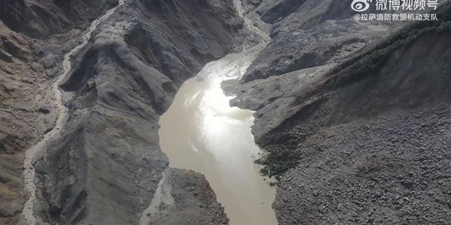
The immediate disaster created a secondary hazard that now threatens both rescue personnel and downstream communities in Nepal. Massive volumes of debris choked the confluence of mountain rivers in Tibet, forming unstable natural barriers known as landslide dams or barrier lakes.
These temporary impoundments collect millions of cubic meters of water with no controlled outlet. As continuous rainfall feeds into these blocked basins, the water pressure builds against walls composed entirely of loose earth, silt, and rock. Chinese state media and Nepalese authorities issued urgent warnings after a barrier lake upstream began overflowing and subsequently breached its makeshift containment.
Emergency responders operating in the Rasuwa district were ordered to drop their equipment and scramble up adjacent hillsides as river gauges registered a sudden, dangerous spike in water volume. This constant shadow of a secondary outburst flood has forced officials to suspend search operations intermittently, agonizing families waiting for news of the missing.
Accelerating Climate Pressures in the Third Pole
The catastrophe underscores a stark reality facing the Hindu Kush Himalayan region, often referred to as the Earth's Third Pole. Scientific assessments indicate that this mountain range is warming at roughly twice the global average. Mountain permafrost—the frozen ground that acts as a structural anchor for steep slopes and hanging glaciers—is degrading rapidly under sustained atmospheric heating.
When this permafrost thaws, slopes lose their structural integrity. Glaciers recede and leave behind unstable moraine walls and precarious ice fields that are increasingly susceptible to sudden failure. Past events in neighboring regions, such as the catastrophic flash flood in Uttarakhand, demonstrated how quickly localized ice and rock avalanches can transform into devastating transboundary disasters.
Governments across the Himalayan arc face an urgent reckoning regarding early warning architecture and cross-border data sharing. Traditional meteorological monitoring systems are poorly equipped to detect sub-surface permafrost degradation or micro-seismic shifts in remote glacial zones. Establishing real-time telemetry along high-altitude river systems requires unprecedented international cooperation between nations where geopolitical tensions frequently complicate rapid information exchange.
For now, attention remains focused on the muddy riverbanks where families continue to search for survivors. As rescue helicopters circle through narrow mountain passes between rainstorms, the true scale of the vulnerability etched into these valleys becomes glaringly apparent. The waters may eventually recede, but the structural risks across the roof of the world will continue to grow long after the emergency responders depart.