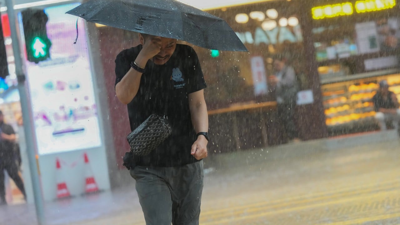
The cancellation of an Amber Rainstorm Warning by the Hong Kong Observatory (HKO) often signals a collective sigh of relief for millions of commuters, but for those watching the radar, it raises uncomfortable questions about the city's aging infrastructure and the increasing unpredictability of the Pearl River Delta’s climate. When the HKO lowered the signal recently, it ended hours of localized flooding and transit delays. While the immediate threat passed, the event highlighted a growing gap between meteorological data and the lived experience of citizens caught in "micro-bursts" that the current warning system struggles to categorize.
Hong Kong relies on a three-tiered color-coded system—Amber, Red, and Black—to dictate everything from school closures to financial market pauses. This system is binary by nature. It triggers at specific rainfall thresholds: 30mm, 50mm, and 70mm per hour. However, the atmosphere does not follow a spreadsheet. The recent storm cycle demonstrated that a "cancelled" warning does not mean the danger has evaporated; it often means the rain has simply moved three kilometers to a district with less drainage capacity.
The Mathematical Trap of Rainfall Thresholds
The HKO operates on a mandate of regional averages. This is where the frustration begins for residents in the New Territories or the narrow canyons of Kowloon. To trigger an Amber warning, the HKO must measure or expect more than 30mm of rain across a "wide area" of Hong Kong.
If a massive cloud dumps 60mm of rain on Sha Tin but leaves Central bone dry, the citywide average might not hit the technical requirement for a Red or even an Amber warning until the damage is already done. This creates a dangerous lag. By the time the sensors register the average, the street-level reality has already shifted from "wet" to "dangerous." The cancellation of a warning is often based on the same flawed averaging. A storm can be tapering off globally while still funneling lethal amounts of runoff into specific lowland villages.
We are seeing a shift in how rain falls. It is no longer a steady, predictable blanket. Instead, we face intense, localized "rain bombs." The HKO’s reliance on fixed gauges means they are often chasing the storm rather than getting ahead of it.
Infrastructure Fatigue and the Drainage Gap
Even when the rain stops and the signals are tucked away, the water remains. Hong Kong’s drainage system is a marvel of 20th-century engineering, featuring massive underground storage tanks and mountain-side catchwaters. But these systems were designed for historical norms that no longer exist.
Every time an Amber warning is cancelled, the focus shifts to the "all clear." What is ignored is the saturation level of the soil. Landslips in Hong Kong are not just a product of active rain; they are the result of cumulative moisture. When the HKO cancels a warning, the public perceives a return to safety. In reality, the hillsides remain at their most vulnerable state hours after the clouds have cleared.
The maintenance of these systems is a grueling, invisible battle. Silt, urban debris, and construction runoff constantly clog the arteries of the city. When a storm warning is downgraded, the pressure on the Drainage Services Department actually increases. They have a narrow window to clear the debris before the next cell develops. The current reporting cycle focuses on the "warning" as the event, when the true story is the state of the infrastructure left behind.
The Economic Ripple of a Cancelled Signal
There is an immense hidden pressure on the HKO to avoid "over-warning." A Black Rainstorm Warning effectively freezes the Hong Kong economy. Schools close, the stock market halts, and the transport network grinds to a standstill. This creates a high-stakes environment for meteorologists.
If they keep a warning active for too long, they face criticism from business interests regarding lost productivity. If they cancel it too early and a flash flood occurs, they face public outrage. This creates a conservative bias in the forecasting model. The recent cancellation followed this pattern: the radar showed a clearing trend, the technical thresholds were no longer being met, and the signal was pulled. But for a delivery driver on a motorbike or a shopkeeper in a basement unit in Mong Kok, the technical "all clear" is irrelevant if the street is still a river.
The Localization Problem
Technology should, in theory, solve the transparency issue. The HKO’s mobile app provides real-time radar, but it puts the burden of interpretation on the citizen. We are moving toward a world where a citywide warning is too blunt an instrument.
Imagine a system where warnings are hyper-local. Instead of a blanket Amber warning for the entire territory, residents receive "neighborhood-specific" alerts based on topographical risk. This exists in smaller scales elsewhere, but the HKO has been slow to adopt a decentralized warning model. They fear that a fragmented system would cause mass confusion during the morning commute.
Instead, they stick to the territory-wide signals, which leads to the "crying wolf" effect. When people in a dry district see an Amber warning, they stop taking the system seriously. When people in a flooded district see the warning cancelled, they lose trust in the institution.
The Soil Moisture Variable
One factor consistently overlooked in the HKO’s public updates is the state of the ground itself. Hong Kong is a city built on steep slopes of decomposed granite. This material behaves predictably until it doesn't.
After a prolonged period of Amber-level rain, the "shear strength" of the soil—its ability to stay on a hill—decreases. When the rain stops and the sun comes out, the water inside the hill starts to move. This internal movement can trigger a landslide even under a clear blue sky. By focusing purely on "rainfall per hour" as the metric for warnings, the HKO ignores the geological reality of the city. A cancelled rain warning is not a "landslip-free" guarantee, yet the public treats it as such.
The Future of the Forecast
We are entering an era of "wet bulb" events and atmospheric rivers that defy the historical data used to calibrate the HKO’s models. The recent storm was a warning in more ways than one. It showed that the transition from a storm to a "clear" status is becoming more chaotic.
The HKO needs to move away from the three-color binary. The future of urban safety lies in predictive modeling that accounts for drainage capacity and soil saturation in real-time, rather than just measuring how much water has fallen into a bucket in the last sixty minutes.
The city is currently playing a game of catch-up with its own climate. Every time a warning is cancelled while streets are still submerged, the credibility of the system takes a hit. We cannot manage a 21st-century climate crisis with a 1980s warning structure.
The next time the Amber signal drops, look at the gutters, not the app. If the water is still rising, the "all clear" is just a statistical illusion.