The environmental sector is celebrating a ghost.
A recent wave of updated mapping surveys claims to have "discovered" thousands of hectares of previously unrecorded ancient woodland. The mainstream media swallowed the narrative whole. They are treating this data correction like a miraculous ecological victory, as if nature suddenly reclaimed vast swathes of land while we weren't looking.
It is a comforting delusion. But it is fundamentally wrong.
We did not find "more" ancient woodland. We merely updated a flawed, forty-year-old bureaucratic ledger. Swapping a pencil for a GPS does not magically summon biodiversity, nor does it undo centuries of fragmentation. By treating a paperwork correction as an environmental triumph, we are falling into a dangerous trap: substituting administrative compliance for actual ecological restoration.
The Paperwork Fallacy: Discovery vs. Existence
Let's dismantle the primary misunderstanding immediately. To discover something implies a net gain. If you find twenty dollars in an old coat pocket, your bank account changes. If a surveyor changes a polygon on a digital map from "secondary woodland" to "ancient semi-natural woodland," the physical reality on the ground changes by exactly zero percent.
The trees were already there. The soil biology was already there. The mycorrhizal networks—the complex underground fungal systems that truly define ancient soil—were already operating under the exact same environmental pressures they faced yesterday.
The original ancient woodland inventories, compiled back in the 1980s, were notoriously crude. They relied heavily on historical maps, manual aerial photography interpretation, and a rigid threshold that often ignored pockets of land under two hectares. Modern technology—specifically LiDAR (Light Detection and Ranging) and digitized historical tithe maps—allows us to spot smaller, fragmented remnants that the original surveyors missed.
This is an exercise in auditing, not ecology.
I have spent years analyzing land-use data and watching organizations pour millions into bureaucratic mapping exercises. They celebrate these data updates because it allows them to hit artificial conservation targets without lifting a single spade or confronting a single hostile developer. It is greenwashing via data entry.
Why More Map Polygons Equal Less Real Protection
The immediate defense from conservation bureaucrats is predictable: "But mapping these sites gives them legal protection!"
Does it? Let's look at how environmental policy actually functions in the real world, rather than on paper.
The Dilution Effect
When you artificially inflate the recorded quantity of a critically endangered resource, you inadvertently lower its political and economic capital. If a country suddenly announces it has 30% more ancient woodland than previously thought, the psychological urgency to protect every square meter drops.
The Mitigation Banking Loophole
Developers do not fear maps; they employ lawyers who know how to navigate them. In the planning system, ancient woodland is technically irreplaceable. In practice, however, its presence triggers "compensation strategies."
Imagine a scenario where a commercial rail line or a housing development cuts through a newly mapped three-hectare ancient copse. Developers will argue that since the regional inventory has suddenly found hundreds of "new" hectares elsewhere, the localized loss is statistically negligible. They will offer to plant 30,000 saplings elsewhere as a trade-off—a classic ecological scam, given that a plastic tube with a twig inside cannot replicate a 400-year-old soil ecosystem.
The Fragmented Remnant Myth
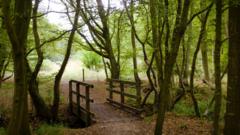
Most of these "newly discovered" woodlands are tiny, isolated fragments—often linear strips along old parish boundaries or steep gullies.
Eco-bureaucrats treat a hectare of fragmented hedge-line woodland identically to a hectare within a contiguous 500-hectare forest matrix. This violates basic island biogeography principles established by Robert MacArthur and E.O. Wilson. A half-hectare fragment has a massive edge-to-area ratio. It is highly vulnerable to:
- Agricultural chemical drift (nitrates and pesticides from adjacent fields)
- Invasive species colonization
- Microclimatic stress (increased windthrow and drying from sun exposure)
Mapping a dying, nitrogen-choked strip of trees and labeling it "ancient woodland" does not save it. It just documents its demise with greater precision.
The Brutal Truth About Soil vs. Trees
The fundamental mistake made by the public—and encouraged by lazy journalism—is confusing trees with woodland.
A woodland is not a collection of trees. A woodland is a complex, historically continuous soil community. The trees are merely the most visible output of that community.
+------------------------------------------------------------------------+
|                      THE ECOLOGICAL MISALIGNMENT                       |
+------------------------------------------------------------------------+
| NOVICE CONSERVATION VIEW:                                              |
| Tree Canopy  ===> Dictates Ecosystem Value                             |
|                                                                        |
| REALITY:                                                               |
| Intact Soil Microbiome ===> Dictates Canopy Health & True Antiquity    |
+------------------------------------------------------------------------+
When we look at the criteria for ancient woodland, the UK standard uses the year 1600 as a benchmark. Why? Because that date roughly marks the period before commercial tree plantations became widespread. If a piece of land has been continuously wooded since 1600, its soil has likely never been plowed, cleared, or heavily fertilized.
That undisturbed soil structure is what makes it irreplaceable. It houses specific communities of ancient woodland indicators—plants like wood anemone (Anemone nemorosa), wood sorrel (Oxalis acetosella), and specific slow-colonizing lichens and beetles that cannot cross open fields.
Many of the newly mapped sites have been highly disturbed. A patch of trees might have remained since 1600, but if it was heavily grazed by cattle for two centuries, or if nearby drainage ditches lowered the water table, the interior ancient woodland ecosystem is already functionally extinct. The map says "Ancient." The soil says "Dead."
Dismantling the "People Also Ask" Defensiveness
When you challenge this narrative, defenders of the conservation status quo throw up predictable questions. Let’s answer them with zero sugar-coating.
"Isn't any data improvement inherently good for conservation?"
No. Data collection has a massive opportunity cost. Every pound sterling spent on satellite imagery analysis, GIS licensing, and bureaucratic validation panels is a pound stripped away from physical land management.
We are deer-fencing nothing, removing invasive rhododendrons from nothing, and buying up buffer land for nothing while we sit in climate-conditioned offices staring at colorful GIS layers. We are accurately measuring the decline instead of stopping it.
"If we don't map it, how can we stop planners from building on it?"
Planners build on mapped ancient woodland anyway. Look at the construction of high-speed rail networks or major highway expansions; when infrastructure demands it, overrides are granted, and "biodiversity net gain" metrics are manipulated to balance the ledger.
The defense of nature does not happen on a digital map; it happens through aggressive, physical land acquisition and radical statutory protection that cannot be bought off with offset credits.
The Uncomfortable Action Plan We Actually Need
If we want to move past the superficial celebration of updated spreadsheets, we have to change our entire approach to woodland conservation. This requires adopting policies that are politically difficult and expensive.
1. Enforce Mandatory Buffer Zones
Stop focusing on the boundaries of the woodland itself. If you find a three-hectare ancient woodland fragment, the law should immediately mandate a 100-meter agricultural-free buffer zone around its entire perimeter. This buffer must be taken out of intensive production and allowed to naturally regenerate. This directly addresses the edge-effect vulnerabilities that threaten fragmented sites, absorbing chemical drift and reducing wind damage.
2. Defund the Mapping, Fund the Management
We must freeze funding for broad-scale inventory updates and redirect those resources exclusively toward active, on-the-ground management of known sites. Ancient woodlands are suffering far more from a lack of management than a lack of mapping. They are being choked out by unchecked deer populations that eat every emerging sapling, overgrown by invasive species, and suffer from a total lack of traditional coppicing that once maintained structural diversity.
3. Ban All Ancient Woodland Offsetting
We must eliminate the concept of "compensatory planting" for ancient habitats. The law must state that if a development touches a verified ancient woodland soil profile, the development is canceled. No exceptions, no mitigation banking, no financial buyouts. If the habitat is truly irreplaceable, then its economic value must be treated as infinite.
The celebration over "found" woodland is an exercise in systemic self-soothing. We are rearranging the digital deckchairs on an ecologically melting iceberg. Stop looking at the updated maps, look at the degraded state of the actual habitat, and realize that we are running out of time to save what is left.